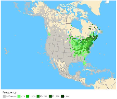
This is important to know when viewing the maps: they present all data from all months from 2003- 2008. So, you're seeing all accepted sightings of breeding, wintering, dispersing, migrating, and wandering birds.
 Last week's quiz, the first taking into account all of the Americas.
Have a guess, then find out if you were right on the eBird site.
Click on the image for a larger version.
I find the process fun (the product of a warped mind, I suppose), and very paradoxical: it's not as easy as it sounds, but it's not as hard, either. I doubt many people will think it's easy, unless your name also happens to be on the cover of a field guide and you've spent years of your life assembling data to produce similar maps.
But taking some time to digest what you're seeing, such as concentrations of sightings, areas of infrequent sightings, locations completely lacking the species, or a scatter-shot of non-contiguous sightings, you can start to eliminate obvious groups of birds and, if persistent, whittle it down the right species.
 This week's quiz. The answer should be up on eBird soon,
but try and figure it out based on what you see.
Click on the image for a larger version.
Feel free to leave guesses and/or answers in the comments, along with your reasoning. AT the moment I have no idea what it is, but I'm hoping a bit of thinking later this evening will help me narrow it down. Good luck!
-


No comments:
Post a Comment